webgl端,倾斜摄影影像能正常加载,分层分户信息查询失败,用的是的是超图在线的individualInformation,我的底部高程字段是altitude1,层高字段是height1
<script type="text/javascript">
    /*示范代码说明:
     *分层分户信息查询
     *
     *主要涉及接口:
     *setQueryParameter
     *setPolygonoffset
     *
     * 示范代码:
    */
    function onload(Cesium) {
        var viewer = new Cesium.Viewer('cesiumContainer');
        var scene = viewer.scene;
        scene.globe.show = false;

        /* 气泡相关 1/4 start */
        var scenePosition = null; // 记录在场景中点击的笛卡尔坐标点
        var dock = false; // 是否停靠
        var infoboxContainer = document.getElementById("bubble");
        var table = document.getElementById("tab"); // 气泡内的表格
        $("#bubblePosition").click(function(){ // 停靠状态切换
            dock = !dock;
            if($("#bubblePosition").hasClass("fui-export")){
                $("#bubble").removeClass("bubble").addClass("float");
                $("#bubblePosition").removeClass("fui-export").addClass("fui-bubble");
                $("#bubblePosition")[0].title = "悬浮";
                $("#bubble").css({'left' : '82%','bottom' : '45%'});
                $("#tableContainer").css({'height':'350px'});
            } else if($("#bubblePosition").hasClass("fui-bubble")){
                $("#bubble").removeClass("float").addClass("bubble");
                $("#bubblePosition").removeClass("fui-bubble").addClass("fui-export");
                $("#bubblePosition")[0].title = "停靠";
                $("#tableContainer").css({'height':'150px'});
            }
        });
        $("#close").click(function(){ // 关闭气泡
            $("#bubble").hide();
        });
        scene.postRender.addEventListener(function(){ // 每一帧都去计算气泡的正确位置
            if (scenePosition && !dock) {
                var canvasHeight = scene.canvas.height;
                var windowPosition = new Cesium.Cartesian2();
                Cesium.SceneTransforms.wgs84ToWindowCoordinates(scene, scenePosition, windowPosition);
                infoboxContainer.style.bottom = (canvasHeight - windowPosition.y + 45) + 'px';
                infoboxContainer.style.left = (windowPosition.x - 70) + 'px';
                infoboxContainer.style.visibility = "visible";
            }
        });
        /* 气泡相关 1/4 end */

        var camera = scene.camera;
        var lastHouseEntity = null; // 最后一次显示的高亮面

        // 加载倾斜摄影图层
        var promise = scene.addS3MTilesLayerByScp("http://localhost:8090/iserver/services/3D-buildings2/rest/realspace/datas/group/config", {
            name: 'oblique photography'
        });

        promise.then(function (obliqueLayers) {
            camera.setView({ // 精确定位
                //将经度、纬度、高度的坐标转换为笛卡尔坐标
                    destination :Cesium.Cartesian3.fromDegrees(113.8631096864043100,34.0455913220827850,1024)
            });

            var handler = new Cesium.ScreenSpaceEventHandler(scene.canvas);
            handler.setInputAction(function (e) {
                // 获取点击位置笛卡尔坐标
                var position = scene.pickPosition(e.position);
                if (!position) {
                    position = Cesium.Cartesian3.fromDegrees(113.8635846473392800,34.0453934017189750,0);
                }
                scenePosition = position; // 气泡相关 2/4
                // 从笛卡尔坐标获取经纬度
                var cartographic = Cesium.Cartographic.fromCartesian(position);
                var longitude = Cesium.Math.toDegrees(cartographic.longitude);
                var latitude = Cesium.Math.toDegrees(cartographic.latitude);
                var height = cartographic.height;

                // 设置查询条件。Z在本例数据中代表户型面的底部高程,CENGG为层高,SmSdriW为最西边的经度,SmSdriE为最东边的经度,SmSdriS为最南边的纬度,SmSdriN为最北边的纬度
                doSqlQuery(`altitude1 < ${height} and ${height} < (altitude1 + height1) and ${longitude} > SmSdriW and ${longitude} < SmSdriE and ${latitude} > SmSdriS and ${latitude} < SmSdriN`);
            }, Cesium.ScreenSpaceEventType.LEFT_CLICK);

            // 去除加载动画
            $('#loadingbar').remove();
        });

        function onQueryComplete(queryEventArgs) {
            // 首先移除之前添加标识实体
            if (lastHouseEntity) {
                viewer.entities.remove(lastHouseEntity);
                lastHouseEntity = null;
            }
            var selectedFeature = queryEventArgs.originResult.features[0]; // 选中楼层的楼层面信息对象
            if (!selectedFeature) {
                /* 气泡相关 3/4 start */
                scenePosition = null;
                $("#bubble").hide();
                /* 气泡相关 3/4 end */
                return;
            }
            if (!selectedFeature.geometry.points) {
                return;
            }
            var bottomHeight = Number(selectedFeature.fieldValues[selectedFeature.fieldNames.indexOf('ALTITUDE1')]); // BOTTOM -底部高程 altitude1
            var extrudeHeight = Number(selectedFeature.fieldValues[selectedFeature.fieldNames.indexOf('HEIGHT1')]); // LSG -层高(拉伸高度)height1

            Cesium.GroundPrimitive.bottomAltitude = bottomHeight; // 矢量面贴对象的底部高程
            Cesium.GroundPrimitive.extrudeHeight = extrudeHeight; // 矢量面贴对象的拉伸高度
            var points3D = []; // [经度, 纬度, 经度, 纬度, ...]的形式,存放楼层面上的点坐标
            for (var pt of selectedFeature.geometry.points) {
                points3D.push(pt.x, pt.y);
            }
            lastHouseEntity = viewer.entities.add({
                polygon: {
                    hierarchy: Cesium.Cartesian3.fromDegreesArray(points3D),
                    material: new Cesium.Color(223/255, 199/255, 0/255, 0.4)
                },
                clampToS3M: true // 贴在S3M模型表面
            });

            /* 气泡相关 4/4 start */
            $("#bubble").show();
            for (i = table.rows.length-1;i > -1;i--){
                table.deleteRow(i);
            }
            for(var index in selectedFeature.fieldNames){
                var newRow = table.insertRow();
                var cell1 = newRow.insertCell();
                var cell2 = newRow.insertCell();
                cell1.innerHTML = selectedFeature.fieldNames[index];
                cell2.innerHTML = selectedFeature.fieldValues[index];
            }
            /* 气泡相关 4/4 end */
        }

        /**
         * 执行SQL查询
         * @param SQL SQL查询条件
         */
        function doSqlQuery(SQL) {
            var getFeatureParam, getFeatureBySQLService, getFeatureBySQLParams;
            getFeatureParam = new SuperMap.REST.FilterParameter({
                attributeFilter: SQL
            });
            getFeatureBySQLParams = new SuperMap.REST.GetFeaturesBySQLParameters({
                queryParameter: getFeatureParam,
                toIndex: -1,
                datasetNames: ['buildingTest'] // 本例中“户型面”为数据源名称,“专题户型面2D”为楼层面相应的数据集名称
            });
            var url = "http://localhost:8090/iserver/services/data-buildings2/rest/data"; // 数据服务地址
            getFeatureBySQLService = new SuperMap.REST.GetFeaturesBySQLService(url, {
                eventListeners: {
                    "processCompleted": onQueryComplete, // 查询成功时的回调函数
                    "processFailed": processFailed // 查询失败时的回调函数
                }
            });
            getFeatureBySQLService.processAsync(getFeatureBySQLParams);
        }

        function processFailed(queryEventArgs) {
            alert('查询失败!');
            console.log(queryEventArgs);
        }
    }
    </script>
</body>
</html>
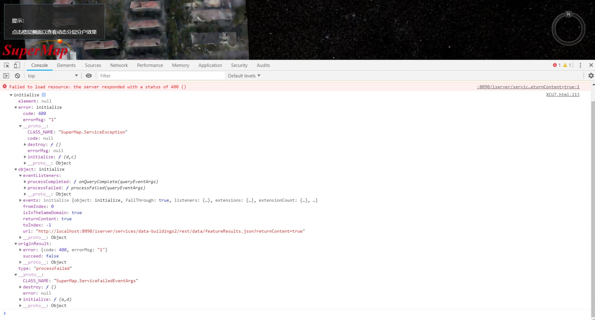
错误信息如图(谷歌浏览器):
 帮我看下,谢谢了!


