在桌面端把麻点加载到图层里,关闭图层眼睛,然后在前端渲染麻点并叠加到其它底图上(底图是国家2000坐标,然后我就把示例代码里的4326坐标注释了),发现麻点不会自动避让且全部显示。而且麻点图标全是黑圆点,改不成其它符号库里的符号,请问怎么办?
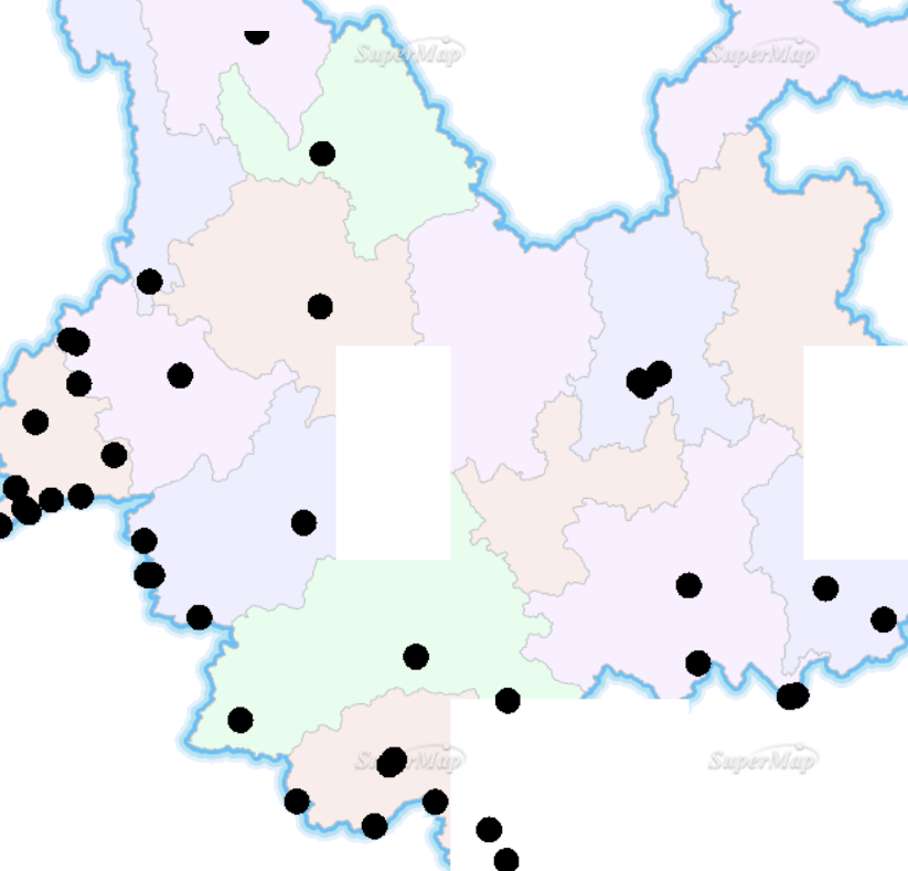
下图麻点不会自动避让了,而且麻点符号改不了(假如麻点和底图是在一幅地图里则可以改麻点符号)
<!DOCTYPE>
<html>
<head>
    <meta http-equiv="Content-Type" content="text/html; charset=utf-8" />
    <title>麻点图</title>
    <style type="text/css">
        body{
            margin: 0;
            overflow: hidden;
            background: #fff;
        }
        #map{
            position: relative;
            height: 700px;
            border:1px solid #3473b7;
        }
        #toolbar {
            position: relative;
            padding-top: 5px;
            padding-bottom: 10px;
        }
    </style>
    <link href='./css/bootstrap.min.css' rel='stylesheet' />
    <link href='./css/bootstrap-responsive.min.css' rel='stylesheet' />
    <script src='../libs/SuperMap.Include.js'></script>
    <script type="text/javascript">
        var map,datasetName,popup,myGOIs,control,
                host = document.location.toString().match(/file:\/\//)?"http://localhost:8090":'http://' + document.location.host,
//                url="http://localhost:8090/iserver/services/map-china400/rest/maps/China";
//                url="http://localhost:8090/iserver/services/map-China100/rest/maps/China";
                url0="http://localhost:8090/iserver/services/map-arcgis-YNBasicMap/rest/maps/YNBasicMap";
                url1="http://localhost:8090/iserver/services/map-YNMAP/rest/maps/YNMAP1";


        function init(){
            map = new SuperMap.Map("map",{controls: [
                new SuperMap.Control.LayerSwitcher(),
                new SuperMap.Control.ScaleLine(),
                new SuperMap.Control.Zoom(),
                new SuperMap.Control.Navigation({
                    dragPanOptions: {
                        enableKinetic: true
                    }
                })],allOverlays: true//,projection: "EPSG:4326"//底图坐标是EPSG:4490,而JS不带4490所以注释了4326
            });
            layer0 = new SuperMap.Layer.TiledDynamicRESTLayer("YNBasicMap", url0, {transparent: true, cacheEnabled: true}, {maxResolution:"auto"});
            layer0.events.on({"layerInitialized":addLayer0});
            createLayer();//加载完地图后渲染麻点图
        }
        function addLayer0() {
            layer1 = new SuperMap.Layer.TiledDynamicRESTLayer("YNMAP1", url1, {transparent: true, cacheEnabled: true}, {maxResolution:"auto"});
            layer1.events.on({"layerInitialized":addLayer1});
        }
        function addLayer1() {
            map.addLayers([layer0,layer1]);
            map.setCenter(new SuperMap.LonLat(102, 24.5), 7);
        }

        function createLayer(){
//            datasetName = "China_Rural_pt@China";
            datasetName = "organization@jyjy";


//创建一个麻点图对象
            myGOIs = new SuperMap.GOIs({
                "url":url1,
                "datasetName":datasetName,
                "style":new SuperMap.REST.ServerStyle({
                    "markerSymbolID":72,
                    "markerSize":10
                }),
                "pixcell": 16
            });

            myGOIs.events.on({
                "initialized":GOIsInitialized
            });
        }

        function clearLayer(){
            closeInfoWin();

            var layers = myGOIs.getLayers();
            for(var i=0;i<layers.length;i++){
                map.removeLayer(layers[i]);
            }
            myGOIs.destroy();
            myGOIs = null;

            control.destroy();
            control = null;
        }

        function GOIsInitialized(){
            var layers = myGOIs.getLayers();
            map.addLayers(layers);

            control = new SuperMap.Control.GOIs(layers,{
                onClick:function(evt){
                    var lonlat = evt.loc;
                    var name = evt.data.NAME;
                    var img = evt.data.IMG;
                    var introduction=evt.data.INTRODUCTION;

                    openInfoWin(lonlat,name,img,introduction);
                },
                highlightIcon:new SuperMap.Icon('img/poi/circle.png', new SuperMap.Size(20,20), new SuperMap.Pixel(-8, -8)),
                isHighlight:true
            });
            map.addControl(control);
        }

        function openInfoWin(lonlat,name,img,introduction){
            closeInfoWin();
            var width;
            var style;
            if(introduction.length==0){
                width="width:0";
                style="\' style=\'float:left;margin:3px 0px 3px 16px;width:270px\'"
            }
            else{
                width="width:450";
                style="\' style=\'float:left;margin:0px 6px -1px 6px;width:270px\'"
            }
            var contentHTML = "<div style=\'font-size:.8em; opacity: 1; overflow-y:hidden;\'>";
            contentHTML += "<div><h6>"+name+"</h6></div><div ></div><img src=\'img/jyjy/"+img+style+"><p style='"+width+"'>"+introduction+"</p></div>";

            popup = new SuperMap.Popup.FramedCloud("popwin",new SuperMap.LonLat(lonlat.lon,lonlat.lat),null,contentHTML,null,true,function(){
                closeInfoWin();
                control.removeClickedMarker();
            });
            map.addPopup(popup);
        }

        function closeInfoWin() {
            if (popup) {
                try {
                    map.removePopup(popup);
                }
                catch (e) {
                }
            }
        }
    </script>
</head>
<body onload="init()">
<div id="toolbar">
    <input type="button" class="btn" value="渲染麻点图" onclick="createLayer()" />
    <input type="button" class="btn" value="清除" onclick="clearLayer()" />
</div>
<div id="map"></div>
</body>
</html>


